Saturday, July 28, 2012

Yosemite National Park


After spending Christmas in San Francisco I drove on to Yosemite National Park, which is a few hours away from San Francisco. I arrived in Yosemite in the late afternoon on Christmas Day, with enough time to scout a location to shoot for sunset. Even on Christmas Day there were quite a few visitors in the park. Luckily I was able to find a location that I had all to myself when it came time to start making images. There was snow when I arrived at the park and it looked like it had fallen a couple of days earlier. It was a fairly mild evening with temperatures hovering in the mid-30's, which made for some beautiful fog that hovered just off the ground throughout the floor of the valley. The fog also meant that the trees and shrubs were all covered in frost.


After the sun had set I drove around for a little while looking for locations to do some star shooting once it was dark enough. I found a couple more fantastic spots and as soon as the stars became visible, I was shooting again. I had a wonderful time shooting the stars in Yosemite Valley, and I have a feeling that is something that not many people have done. I have seen many images of Yosemite, but only one or two night-time images. There was a little bit of moonlight which provided some nice illumination on the rocky cliffs. The moonlight wasn't bright enough to wash out the stars, though. And boy, let me tell you.... rarely have I seen a sky so full of stars! It was an incredible night, one I will not soon forget!


I returned to Yosemite again the following day, but the conditions for photography were less than favorable. It was a chilly, damp day with gray skies. I ended up driving around some more on the park roads to some areas that I hadn't seen the day before, but I really didn't take any pictures. I also visited the Ansel Adams Gallery, which is located near the park's visitor center. The gallery is definitely worth a visit. They have some really amazing framed prints of some of Ansel's most famous images, as well as images by other photographers that are well worth a look. Do yourself a favor and check it out if you ever find yourself in Yosemite!

Friday, July 27, 2012

Low Trail Madness

Mike Flanigan Tries a Rawland

While I've wished for this to happen, I doubted that it actually would: Low trail, 650B bicycles entering into standard production. But the day has arrived, and it arrived with an email from Soma Fabrications. An e-buddy of mine over there informs me that they will soon release a "Grand Randonneur" model, co-designed with Boulder Bicycles/Rene Herse."Is this public knowledge?" I asked, wiping the spray of coffee off my keyboard. Not really, was the reply, but I was welcome to make it such. "Just note that it’s still unofficial, and some of the details may change before production." Noted. Oh, and do I want to test-ride the prototype once it's ready? As if they had to ask.


The Soma announcement came on the heels of Rawland's release of the Stag: a model similar to the Nordavinden, only with slightly different specs. The pre-order pricetag is $625 including a free set of Pacenti PL23 rims. I imagine Soma will try to get its pricepoint in the same range. Adding the $500 Velo Orange Polyvalentto the mix, that gives us 3 manufacturers offering standard production low trail 650B framesets, made in Taiwan, for well under $1,000.


For those who prefer a US-made bike, there are several pre-fab models available in the $1,500 range, including the Box Dog Pelican, the Boulder Randonneur, and most recently the Rambler from Ocean Air Cycles.If you've ever wanted to try a bike like this without the wait, uncertainty and pricetag of going full custom, there are options.


But speaking of custom, more and more framebuilders are testing the waters with low trail 650B designs and some of the names may surprise you. As I write this, I am eying a fresh-off-the-boat prototype frameset from Mercian Cycles in England that was built to my spec. (For the record, they are skeptical of the low trail design, so if the bike doesn't ride well I take full responsibility.) Equally surprising is that Seven Cyclesare willing to give it a go, in titanium of course. Jokingly I asked them about it a little while ago, and the reply was "Let's talk."


So what's so special about low trail? In a sense, nothing, and that's sort of the point. Some of us simply believe it to be a "normal" geometry just like any other that happens to be useful in some contexts and beneficial for some riders. This does not mean that it's special or better, but only that we feel it ought to exist as a viable option. Personally, I've come to appreciate the feel of low trail on city bikes, as well as on fat tire bikes ridden on dirt; the combination of how responsive and at the same time intuitive these bikes feel intrigues me. But of course not everyone agrees. The husband tolerates low trail on his Brompton, because he finds the bike handy, but dislikes it on roadbikes. And framebuilder Mike Flanigan - tempted to try the Rawland after I raved about its handling - just smiled and shook his head after his ride: "Nope, still don't like low trail" - though he's made a few for customers, and continues to do so.


Is low trail design a fad that will seem silly in hindsight, or an enduring trend that is here to stay? We'll just have to wait and see.

Thursday, July 26, 2012

Scenic Highways

When I left Coral Pink Sand Dunes State Park on the morning of May 12th it was downright cold. I stopped at a roadside rest area on US 89 about 40 miles north (and somewhat higher in elevation) and saw a few trees and plants with tiny icicles hanging off of them!


About 11 am I arrived at the visitor center at Bryce Canyon National Park. There were campsites available, but the temperature was a “brisk” 35ยบ and I opted to continue on my way, knowing that I could return later. I also wanted to stop at Kodachrome Basin State Park, which was nearby, but not when it was so cold.

Utah Route 12, which is the highway that passes by Bryce Canyon and goes north towards Capitol Reef National Park, is a Scenic Byway. And it is quite beautiful. The little bit that I saw of it anyway. It started out rather nicely. But the sky was strange looking. The clouds were blue!

The canyons near Escalante, looking westward. The midway point between Bryce Canyon and Capitol Reef parks.

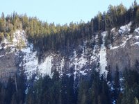
Another view of the canyons, taken 10 minutes later, looking west.

The canyons near Escalante, looking to the north. Uh, oh.

I drove into the clouds and saw no more pretty views for the next hour. It snowed. Quite heavily in some places, but the roads were clear. It snowed all the way through the Boulder Mountains.

Near the summit (9600 feet high) of Boulder Mountain the sky started to clear. Steam was rising from the road surface. It felt quite warm when I stepped out of the van to take the picture. But alas, it was just a temporary clearing. It snowed, and sleeted, and slushed most of the way to Torrey, the turnoff to Capitol Reef.

Once again, I stopped at the visitor center. The campground was full. There was BLM land nearby where I could spend the night if I wished. But it was early afternoon, the weather was lousy and more of the same was predicted for the next day. I opted to continue on my way, knowing that I could return later. At least I glimpsed portions of the scenery as the highway meandered through the park.

A check of the map showed that Goblin Valley State Park was an hours drive to the north on Utah Route 24 so I set my sights on spending the night there, which is what I did.

Shortly after I arrived at Goblin Valley, hail fell. Then it thundered and rained. Along about sunset time I glanced out the window and saw the tail end of a rainbow! Ah, Mother Nature in all her glory!

Yes, the photo is slightly out of focus, but it was such an unexpected and glorious sight that lasted only a few moments. It was there. Then it was gone.

You may think that I “complain” a lot about the weather. It's cold. It's hot. The rain. The snow. But I also frequently mention the beautiful blue skies and sunshine. Mother Nature can be fickle and even cruel at times, but you can be assured of just one thing – she is constantly changing. When you are living “on the road” the conditions “outside” are everything, you become more aware of them. The conditions affect your mood. They affect what you do and when you do it. So, yeah, I talk a lot about the weather. It's all I can do. Can't change it, though sometimes I wish I could.

Sunday, July 22, 2012

Sunroom Painted

These came out kind of dark but this is the sunroom after we painted it. It is a kind of ivory color called White Shell. It was a bit of a chalange to paint with the help of four cats but we got it done. Now we have to do the celling as you can see in the upper corner of the first photo it is not finished. But first things first and we have outside chores to do first.


Doesn't Even Have a Top Tube


Notice Anything Different About This Betty?
Rivendell Betty Foy [review here]


The other day I received an email newsletter from Rivendell, where, among other things, they announced that their mixte model - the Betty Foy - is becoming their most popular bike... which, they promptly added, "wasquite a surprise considering it doesn’t even have a top tube."


Okay, so I know that was meant to be tongue in cheek. At least I think/hope. But it references a sentiment that is prevalent in the bicycle industry: that step-through/mixte frames are inherently inferior to diamond frames and therefore it is not worth making them with the same degree of care, precision and attention to detail. After all, customers are unlikely to buy these frames at the same price point as diamond frames.This idea comes from the fact that the "two triangles" design of the diamond frame construction is stiffer and stronger than any variation of the step-through design, and I do not intend to disagree. But there is more to a bike than that, particularly when we are talking about "real world" bikes. When it comes to accessibility, ease of transporting a rear load, and cycling in one's everyday clothing, step through designs are in fact superior. It is no surprise that people are willing to pay for them.


Soma Buena Vista Mixte 650B
Soma Buena Vista [review here]


When I considered buying a Betty Foy over two years ago, it left me with mixed feelings to read the following in the description of the bike: "This style - mixte, lady's bike, step-thru, whatever you like to call it - came about originally to allow a woman's dress to drape gently down so it wouldn't get blown up by the wind. Most women don't wear dresses anymore, and if they do they don't ride bikes in them; but there remain benefits to this style frame..." And this was the manufacturer talking, trying to sell this bike? Sheesh. Walk into any clothing store or office building, and it is clear that women can and do wear skirts and dresses. And why on earth should they not ride bikes in them?The Betty Foy's popularity is not news to me, or to anyone else who is familiar with the female bicycling blogosphere. Countless women with an online presence pine for this bike, if they don'thave one already. After all, bikes like the Betty and the Soma Buena Vistaare well-suited for hilly, long distance real-world North American commutes, and many women turn to them when Dutch-style bikes prove not to be sufficiently fast or light for their needs. But there aren't enough bikes like this made; we need more.


I was so excited when Velo Orange introduced its lugged mixte in , and I was equally disappointed when they discontinued it in - due, apparently, to less than stellar sales. I have a theory about why the VO mixte did not sell, and I will state it at the risk of being perceived as sexist. My impression is that (despite some vocal commentators ready to argue the opposite) it is women who mostly want mixtes. But VO was reluctant to cater mainly to women, and so they intentionally made the colour scheme aggressively sporty/ masculine just to say "look, this bike really is unisex!" Okay, yes technically it's unisex. But what ended up happening, is that many of the women who would have otherwise loved to buy a lugged mixte frame found the colour scheme unappealing. And the men did not want a mixte in the first place. I have a strong feeling that if VO were to introduce the same frame in a different colour it would sell. I hope very much that they give this a try some day.


Royal H. Mixte, Garden
Royal H Custom Mixte [review here]


Even custom framebuilders have a difficult time constructing lugged step-through and mixte frames, because standard lugs for these designs are no longer available. A few years back Reynolds stopped producing tubing suitable for mixte stays, which is why Mercian has discontinued their classic mixte and now makes only this. I believe there is money to be made in producing batches of split-stay mixte lugs and tubing, for anyone interested.


Bike manufacturers need not be afraid of step-through frames. And they need not be afraid of catering to women. And they need not be afraid of acknowledging the fact that many women wear skirts and dresses, and for this and other reasons they prefer step-through frames. Please do make bikes without top tubes, and make them nice. Rivendell is a case in point that it makes sense financially.

Saturday, July 21, 2012

Souvenirs

While writing my post for the 45th edition of the Carnival of Genealogy, I looked for a picture of this car but couldn't find it then. In the background is our 1956 Nash Rambler Super Sedan, like the one pictured at Old Car and Truck Pictures, about halfway down the page.

My parents had just returned from a fishing trip to northern Minnesota with Dad's sister, Fern, and her husband and daughter. Doug, Jack, Terry and I are showing off the souvenirs they brought us. It was August 1957.

In July that year, Doug, Jack and I had gone on a trip to the Wisconsin Dells with Grandpa Vic and Aunt Shirley. It was the first time that we had been away from our parents and little sister. We were only gone for a few days but we still got homesick, or at least, that is what I've been told - many times!

When Mom and Dad were planning their trip to Minnesota they decided to split up us kids and parcel us out to several aunts and uncles. Doug went to Columbia City to stay with Aunt Phyllis and Uncle Walt. Jack and I were sent to Pierceton to stay with Aunt Jessie and Uncle Toby. Terry went to Goshen to stay with Aunt Leah and Uncle Shocky. I don't remember how long Mom and Dad were gone, probably a week. But at some point during that time someone decided that we kids needed to see each other. So Doug and Terry were brought to Pierceton since that was somewhat the "middle" distance between Goshen and Columbia City.

When the time came for Doug and Terry to go back to their respective temporary homes, apparently we all started crying and quite simply couldn't be separated. Each time one of them would get into the car the crying would resume. I'm sure there is some exaggeration on the part of the adults regarding the extent of the hugging and crying ;-) at least there are no pictures of that! Bottom line, we all ended up staying with Aunt Phyllis in Columbia City for the few remaining days until our parents returned. Hers was a full house with her own four children and the four of us, but comfy. And we were together. And it didn't matter that we had to sleep on the floor!

Thursday, July 19, 2012

Along the Oregon Coast...


The air was cool, the sun was warm, a stiff breeze was blowing, the waves were churning.


Strange formations (natural or man-made?) beneath a cliff below the highway.


Intense blues.


Taking advantage of the sunshine... sadly, it didn't last long.

All photos taken between Newport and Florence on U.S. 101September 29, ..

In Case You Were Wondering...

Yes, I did find someplace cooler! When last I left you, I was sweltering in 100 degree temperatures, along with much of the Midwest and the East Coast! Thursday morning (July 21st) I continued driving through Toledo and on into “Pure Michigan” northward. At Standish (north of the “thumb”) I followed U.S. 23 along the coast of Lake Huron. It was a very nice tree-lined drive with little traffic, but views of the lake were few and far-between. Of course, I could have stopped at one of the many public access areas but the temperature was still near 100 degrees and I was quite comfortable in my air conditioned van!


The temperature did drop the further north I drove but still in the 90s. Oddly enough it wasn't until I turned inland a ways that the temperature dropped into the upper 80s. I spent the night at very pleasant State Park at Onaway on the shores of Black Lake near the upper tip of the Lower Peninsula. The temperature actually got into the 70s overnight. Upper 70s but 70s nevertheless!


It seems that every campground has a different atmosphere to it. Some have open campsites with little privacy but the people seem friendlier there than at the campgrounds where the sites are more secluded. Some, by their very nature – such as those on or near lakes - tend to be noisier than others. It was tempting to spend a few days at Onaway but it was a busy place with lots of kids and dogs and was very noisy.


So on Friday morning I went in search of a more quiet, secluded place where I could simply relax and perhaps work on the research papers I had accumulated while in Ohio...


No, it's not Michigan! But thought I'd share this, which was taken about six weeks ago in the Rocky Mountains. Perhaps it will make someone feel a little cooler during this heat wave ;-)


"My" Billboard!


Yesterday as I drove towards Duluth from Minneapolis I was finally able to see the Grand Portage Lodge and Casino billboard, which has one of my photos of Lake Superior on it. The billboard has been up for several months, but this was the first chance that I had to see it. The picture of the billboard isn't the greatest (its a little fuzzy), as I just snapped it through the windshield as I drove by, but you get the idea. Its pretty exciting to see my photo up there! Here is the image that was used:

http://travisnovitsky.smugmug.com/gallery/6332258_Zj93j#399560384_4ErTU

So, the next time you're driving up towards Duluth on Interstate 35, the billboard is between Forest Lake and Hinckley.... keep your eyes open for it!

Last night's presentation at the spring meeting for the Duluth-Superior Camera Club went very well. Last fall I had been asked by Brian R. to do a slide show and a talk sometime about my photos for the club. As it turns out, the timing for the meeting worked out great as a "bookend" for my trip to the southwest. My slide show and talk concentrated on my newest images from the trip and I wrapped things up by showing a few images from the north shore, to show what it is that always brings me back to the area and what makes the area "home". After the show a number of members from the club came up to me to thank me for coming and tell me how much they enjoyed my work. We also talked "shop" about cameras and the art of image-making. I ran into some friends that I already knew and made some new friends. It was a great evening, one that I enjoyed and I hope the members of the club enjoyed it as much as I did.

Wednesday, July 18, 2012

Watermelon


We waited and watched and watered and waited and finally we had watermelon. It sure was good.
But the kitten couldn't figure out why we wanted to eat such a thing.

Tuesday, July 17, 2012

3 days of shenanigans

Laura and I planned to go ice climbing with my buddy Matt Johns from Kentucky, Joel Torretti and his buddy Josh Hurst from Maine. Yeah you read right, he came here from Maine. After a start consisting of breakfast at Valley Dairy, shopping for - drill bits, a six pack, twice forgotten pants, non-alcoholic drinks, snacks and probably more. We've learned that buying a sixer around 9:00 am is harder to do than you think... Oh yeah I almost forgot it was raining. Not the best weather for ICE climbing, or is it? Well Matt had to stay in Kentucky so we sadly were Mattless. It ended up being Laura, Joel, Josh and I. After our morning shenanigans, we decided to drive to Meadow Run in Ohiopyle to check out the Upper Meadow amphitheater for potential mixed lines. The rains stopped by the time we arrived in Ohiopyle. Upon pulling into the parking lot we saw the quantity of ice along the Lower Meadow cliff band and decided it was clearly time to climb and check out the Upper later in the day. We spent the morning cranking the mixed lines and even added an alternate left var. to Captain Caveman that traverses left more under the roof before pulling the lip around the last hanging curtain. Slightly longer and harder than Captain Caveman. All kinds of shenanigans going on there. Fun stuff... short and pumpy. Laura busted herself up falling on Anger Management (which some asshole stole the draws off of) so she stayed to climb Hemlock with me and following the advice of Dr. Torretti, decided to head home to heal for tomorrow and Sunday. The 3 of us stayed and climbed a couple more lines and decided to walk to Upper Meadow to eye the amphitheater while we still had a couple of hrs. of light. What can I say... Its steep, burly, has free hangers and pillars galore. Its impressive to see. We explored around looking at potential lines out the steep cave. We decided to work on a line that starts on some ice in the back of the cave and heads up through several overlaps to the free hanging curtain at the lip. Burly, but by no means the most difficult line there. Joel rigged a line from the top while Josh started up the ice and got the first bolt in. I put him on belay as he worked up, go into position and placed the 2nd. He came down and I was up. I went up on lead to the high point and continued up into position and located where to put the 3rd. I didn't get more than a 1/2 inch when the drill was doing no good. The battery was dead. I lowered the drill and proceeded to get myself stuck for a while. After much effort, I was back to the ground. We cleaned up and walked out as it was getting dark. Good ice, good laughs, good fun. 1 down 2 to go. Can't wait to see what tomorrow brings... Enjoy the photos!


Monday, July 16, 2012

Camp Patriot

The LA Times interviewed Incident Commander, David Gottlieb, regarding the most recent tragedy on the Muir Snowfield. The details are heart wrenching.

On a much more positive note, wounded veterans from Iraq and Afghanistan are aiming for Rainier's summit. Backpacker Magazine did a story (Shock and Awe) about last year's achievement. That extraordinary effort put a blinded Army Captain on the summit. Look for the team from Camp Patriot on the Disappointment Cleaver later this July.

Speaking of routes, folks are climbing them. We've updated the route conditions page, and posted information about successful attempts on the Emmons and Gibraltar Ledges. Have a great weekend.

Sunday, July 15, 2012

Cycling and Self-Portraiture


I have long been interested in the connection between cycling and amateur self-portraiture. Anyone familiar with the world of bicyclists' image galleries is also familiar with the ubiquitous "panda shots," storefront reflections, snapshots of one's bike shadow. Taken quickly with tiny low-quality cameras, these provide spontaneous glimpses into how we move through the world, what we encounter along the way, and how we relate to our bicycles while doing so. Over the years it has become a distinct genre.


But why do it? Looking in from the outside, it is easy to interpret it as a contemporary obsession with documentation, a marking of territory, or in the case of "panda shots" (pictures of yourself taken while cycling) as a showing off of skill. And of course to some extent it is all that. But what makes it bike-specific? I have never encountered another group outside of the art world that is as prone to self-portraiture as cyclists. Joking around with bikeyface, we tried to start a trend for "walk pandas," but somehow pedestrian self-portraiture does not hold the same appeal.


Last year I wrote aboutbicycle blogs and exhibitionism - describing a culture among the blogs of beginner female cyclists where women communicate and encourage each other by showing pictures of themselves doing everyday bike-related activities. Outside of the intended audience (for example, when observed by experienced male cyclists), this is sometimes misinterpreted as exhibitionism. But for the intended audience it is in fact a "teaching by doing" sort of tool that can be more effective than any advocacy.


Still the trend for self-portraiture among cyclists is not limited to this alone. It is more widespread than that and encompasses a more diverse demographic. From racers to retrogrouches to randonneurs to pedaling fashionistas, cyclists just seem compelled to snap pictures of themselves on or next to their bikes.


It is possible that moving around by bicycle, particularly when we are new to it in adulthood, heightens our sense of self-awareness and it is this that inspires the self-portraiture. In a sense, the cyclist keeps a visual diary. And a true diary, be it written or visual, is more than just about what happens in one's environment; typically the diarist also focuses on themselves.


How well this works as an explanation, I don't know. But as a psychologist and a painter I am fascinated by the tradition of self-portraiture I've seen emerge as more and more cyclists share their images with the world. If you take pictures of yourself on or with your bike, why do you do it?

Saturday, July 14, 2012

Icicle River Gorge Trail ..

Jennifer and I finally got away for a little camping/hiking trip. We drove out to Leavenworth to camp with Matt and his brother Sunday night, and it turned out they had a similar plan for Monday. As Matt put it, "Drive to the end of the road and start walking." I was not aware that Icicle Road was still not fixed, so we headed onward. About five miles from Eight Mile Campground we were met with the road closure.

The road now a river

There was a newer road cut away from the river, but the forest service is not allowing public access by motorized vehicles at this time, so we parked and started walking. The new road is not yet ready for heavy vehicle access and is even susceptable to some flooding early on, where a small bit of rocks and mud is the only thing keeping the river out. It also showed plenty of signs of beavers, which might interfere with the road as well. We hiked on this a bit before it rejoined Icicle Road above the washout. We investigated the upriver side of the washout before proceeding up the road.

The work of beavers

After a while we came to the Chatter Creek trail head. After checking out the board there, (A trail conditions report from August '08 was on it.) we parted ways. Matt and his brother were heading back to Seattle via Washington Pass and Jennifer and I forged on ahead. Just around the corner we found the Chatter Creek Ranger Station. It looked like it was in a state of disrepair, but not too bad considering it has not been used in two years. Just across the road was the start of the Icicle River Gorge Trail. We decided to take it.

Unfortunately, the most dramatic point on the trail is the start where you cross the footbridge over the creek.

View from the bridge

There was some serious whitewater and interesting eroded rock in the constriction under the bridge. We watched a bit before heading up the trail. The trail climbs a short bit to a lookout area above the creek before dropping back down into an area that is more like a Western Washington forest. The ponderosa pines were replaced by western red cedars and the ground cover changed. We started seeing plenty of blooming (and past bloom) trilliums. We hiked on crossing several small bridges and hiking for what seemed like a while. The trail has not been maintained in a few years, but did not have too many logs across it.

Largest trillium I have ever seen

We had started this trip sans packs, and started thinking about getting back as this was a little more than we were thinking about when we left the car. But the trail was nice and we were having a good time. Despite dark clouds in places, we did not get any precipitation while we were out either.

We decided to continue up trail as we expected to be reaching the bridge back across the creek soon. It took longer than we expected, and once we got to a bridge we still appeared to be heading upstream. I quickly ran ahead to make sure we were going the correct way and I was able to see the vehicle bridge at the Rock Island Campground. We were going the correct way. At the campground I checked to see if the water fountains were working, but of course they were not. Since Jennifer and I had not packs, we did not carry any essentials with us including water.

We got back on the trail and headed back toward the car. The trail went quicker on this side of the creek and once again we were in a cedar forest.

Needle carpeted trail

The rest of the hike out was uneventful except for us missing the new road back before locating it. This was a fun hike, and surprisingly populated for a Monday. (We saw two other parties.) Considering the road is closed, it takes a bit of hiking just to get back in there. You could take a mountain bike on the road, but they are not allowed on the trails due to it being a wilderness area. I'd like to explore this area further in the future. It was also nice to get out without a pack on and just go for a walk. Of course, it would have been nice to have some food and water with us, but we survived.

The Forest Service page on the washout

Friday, July 13, 2012

Cold Snap and Frozen Waterfalls

The mountain sustained several days of sub-freezing temperatures between Feb 16th-20th and the trend is expected to continue for the next six days.

During that time numerous frozen waterfalls formed along the Nisqually-Paradise Road. Here are a few images... The approach is rather short, and the ice seems to be getting thicker each day.

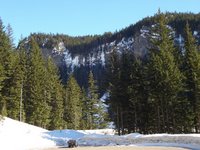
It was cold and blustery Friday and Saturday, particularly on the Muir Snowfield. I ran into a number of parties that turned back from their Camp Muir and/or summit plans because of the winds and temperatures. A few hardy groups did make it to Camp Muir on Saturday night, but those east winds and cold temps intensified with elevation and in the end, most parties lost their summit steam. And rightfully so, I recorded -7° F and a steady 20-25 MPH wind at Camp Muir.

On
Feb 10/11th, Ted cleared a mountain of snow at Camp Muir. Thankfully, his handy work was still intact, as access to the Public Shelter, restroom, and emergeny radio remained easy.

Monday, July 9, 2012

A Most Excellent Adventure :: Sawyer Glacier Number Two

Friday, August 27th - - You may have noticed that I've been saying Sawyer Glaciers rather than Glacier. That's because there are two of them! Twin glaciers. Two “branches” of the same glacier that were divided by a mountain as they came down to the ocean. After spending about two hours at Sawyer Glacier the Captain said we would go on over to “the other one” for a little while. How cool was that?

The first thing we noticed upon approaching Sawyer II was that there wasn't as much ice floating around, compared to the first glacier. Captain Steve said that it wasn't because this one wasn't calving but because there is more wind in this cove and the wind blows the ice out to sea.

If you look very closely (double-click on the image to view a larger version), there is another tour boat in front of the glacier. It is in the middle of the half-circle of rock that is just to the right of the center of the face of the glacier.

The boat isn't as close to the glacier as it appears. They usually stay at least a quarter of a mile away from the face of the glacier.

This one section was so much more intensely blue compared to than the rest. The pressure must have been tremendous to cause it to compress so much.

There were a few seals swimming around, but not nearly as many as at the first glacier.

The snow at the top of the glacier.
Within a few minutes of our arrival the clouds parted a little and the sun came through in spots. It was fascinating to watch the colors of the snow and ice change as the sunshine moved across the face of the glacier.

Again, as with the first glacier, there was quite a bit of activity with falling chunks of ice. Steve kept telling us to keep an eye on two specific areas, one of which was to the right of the intensely blue ice.

As if on cue, the glacier released some of the ice from its grip and down it went!
More ice cascaded down as the waves started building.
A very short time later, the wave reached the boat and we rolled with it for a few seconds.
And then, another big mass gave away and fell...
Which caused another, even larger wave.
Captain Steve told us all to either sit down or grab hold of the railing as we were in for a short but wild ride! He then moved the boat so that it was heading in the same direction that the wave was going. It was an exciting few seconds! We lingered a few more minutes but then Steve said we had to go.

Our stay at Sawyer II wasn't long but it was truly amazing and awesome! From a distance, there doesn't appear to be much change in the face of the glacier. But if you look closely at the left side, you can see where the event occurred. It had been a fantastic day – no rain, whales, seals, beautiful scenery, incredible calving – all shared with strangers who for a short time became friends experiencing amazing sights. It was indeed, a most excellent adventure!